Hampton Township is a suburban community located in the north central area of Allegheny County, Pennsylvania. The Community Park is the heart of the Township’s recreational offerings and is an activity hub for Hampton Township residents. The park contains a variety of sport courts, picnic pavilions, a pool, as well as a 51,000 square foot community center and library. The addition of a multi-use trail had been a top requested added feature in annual community surveys for years.
The Township received a Gaming Economic Development Tourism Fund (GEDTF) grant in 2019 and design of Phase 1 of the 1.5 mile loop trail began. The loop trail design featured 10 foot wide crushed limestone path designed to meet ADA standards for slope and surface. Trail grades were less than 5 percent except for the spurs to the Rachel Carson Trail and the Irma Kost Natural Area which were also included in the project work scope. The length of the trail in Phase 1 was 0.58 miles long plus the added spurs.
Sustainability was a factor in the design. Drainage was designed to meet Best Management Practices to minimize the impact to adjacent park land and park amenities and all topsoil remained on site to filter water and absorb carbon. Solar powered LED luminaires were specified as a sustainable source of lighting along the trail.The project was bid in the Winter of 2020/2021 and completed Summer 2021.
Trans Associates assisted with the funding application, performed the design, prepared plans and bidding documents, and provided construction consultation.
In 2015, Trans Associates was tasked by the Pennsylvania Turnpike Commission (PTC) to complete a Systemwide Truck Parking Improvement Study. The study evaluated existing service plazas and identified other possible locations where land was available to provide truck parking facilities. Lawn Service Plaza was ultimately selected and Trans Associates performed the design of the facility. The goal of this project was to maximize the availability of tractor trailer truck parking at the plaza. The PTC owned adjacent land which was used for this purpose. The design from Trans Associates added 77 dedicated tractor-trailer parking spaces which increased available truck parking by more than five fold.
The project included:
6.3 acres of full-depth concrete pavement for the truck parking and circulation area;
Installation of signing and pavement markings;
Expansion of an existing stormwater detention basin;
Construction of a new, larger stormwater detention basin to protect exceptional value wetlands;
Repaving of an employee parking area and access road;
Relocation of the electric service for the Plaza underground; and
Upgrades to the plaza-wide LED lighting.
Nearly 5 Football Fields in Size!
Additional infrastructure was also installed for video monitoring of the new lot, and to facilitate a future ITS integration which would provide truck drivers on the Turnpike with advance information that would include parking space availability. The Plaza access points were reconfigured in the design, but remained open during construction for daily deliveries, employee arrivals and turnpike access for emergency vehicles.
Safety Design
The truck parking location was designed to be spatially separated from other classes of vehicles and the many pedestrians using the Plaza. There is a wide wide access from the existing truck ramp and wide aisles for turns and maneuvering. Exclusive pull-through parking bays further minimize conflicts between tractor trailers within the new lot. Lighting for the existing Plaza and the new truck parking area was upgraded with efficient LED lighting to provide safety and security for cars, trucks and pedestrians at night. Additional installed security cameras will enhance safety and security for truckers parking overnight.
Trans Associates has proudly served Pickaway County by providing traffic engineering services for more than 10 years. Work scopes have ranged from simple access studies to reviews of traffic studies for large scale developments such as the 383 acre development with 4.4 million SF of automated warehouse space located near Rickenbacker Intermodal Terminal.
Services Performed
Traffic Studies – Consult with County officials on various traffic engineering and/or transportation issues and provide appropriate recommendations.
Traffic Impact Study Reviews – Assist in the definition of items to be addressed in traffic impact studies and review submitted studies.
Engineering reviews – Review of traffic signal plans and preliminary site development plans.
Access Studies – Develop recommendations related to proposed site access and internal circulation systems. Recent project included Circleville’s Heritage Nazarene Church and the reevaluation of site access associated with continuing development of Richenbacker Global Logistics Park.
Consulting – Providing engineering or technical advice on other matters as requested by the County.
Northstar Golf Resort is a development of nearly 1,290 acres in southern Delaware County, Ohio, near the interchange of I-71 with US 36/SR 37. The original development plan called for building approximately 900 single-family homes, 270 multi-family dwelling units, 200 Tennis & Swim Club Villa units, 860,000 square feet of office development, an 18-hole golf course, and a passive recreation park with approximately 36 acres reserved for elementary and middle schools. The 2005 development plan included the improvement and realignment of Wilson Road between North Galena Road and Carters Corner Road – along with the extension of Wilson Road west of North Galena Road and south to a new intersection with US 36/SR 37.
SERVICES PERFORMED
Traffic Studies – Data Collection and analysis, access and circulation studies, traffic signal warrants.
Design – Concept design alternatives for interchange, traffic signal design.
Transportation Planning – Site access and circulation planning, intersection design, roadway design concepts.
Trans Associates is the prime engineer on this one mile widening project in Delaware County, OH. With development increasing in the area, the County wanted to widen the roadway to 24′ with safety shoulders, improve drainage and realign an S-curve to meet a 45-mph design.
SERVICES PERFORMED Transportation Study – The study phase in 2018 determined the most effective storm water management system which informed roadway design.
Roadway Design – Design covered one mile of roadway which included a tie-in point on Steitz Road 450’ north of the project area to match a separate roadway design project underway by others.
Pavement Design – With the exception of potential curve widening along the improved S-curve midway through the existing alignment, TA utilized the existing alignment and profile with a variable-thickness resurfacing course to minimize excavation. The location of longitudinal sawcut lines were determined through an evaluation of the existing pavement condition with the intent to salvage existing pavement where feasible.
Drainage Design – The corridor is located directly along a drainage basin ridge between the Olentangy and Scioto Rivers, creating a lack of drainage outlets for roadway stormwater. TA worked closely with the DCEO to identify and locate existing field tiles that would ultimately be the only positive outlets available to the corridor. A standard ditch section was determined to encroach excessively into residential front yards, and was successfully replaced with a full-length storm sewer system designed with minimal grades to avoid deep trenches. Stormwater BMP’s will be designed to provide water quality and volume.
The Urban Redevelopment Authority (URA) of Pittsburgh received TAP* funding to enhance pedestrian safety in the Homewood neighborhood of Pittsburgh. The goal was to improve pedestrian safety and promote Safe Routes To School in the vicinity of Faison Elementory. Trans Associates provided transportation engineering and design services for the project as a prime contractor to the URA.
The pedestrian needs study to identified and prioritized improvement recommendations. Public meetings were held to present findings and confirm work scope. The PennDOT project development process was used to finalize design plans and prepare documents for bidding on PennDot’s ECMS system.
Design Improvements Included
ADA ramp designs and new sidewalk/curb replacements
Flashing School Speed Limit Warning Devices by Faison Elementary
Improved LED Lighting under the busway and railroad underpasses
New thermoplastic pedestrian crosswalks and signage plan
Street furnishings including benches, bike racks, trash receptacles, tree pits
Traffic calming on Finance Street which included speed humps
Pedestrian scale lighting
* Transporation Alternatives Program funding from PennDOT
Pine Creek Road was the township portion of road that remained after PennDOT relocated Route 19 and built McKnight Road. This segment of road in McCandless Township became an unofficial connection between the two major arterial roadways. Over time, the two lane road was experiencing congestion and delays in both the AM and PM, and as development increased in the area, improving the intersection became a priority.
Challenges for this project included widening an existing two lane arch bridge over Pine Creek that was structurally sound although functionally obsolete. Ultimately a cast-in-place foundation with adjacent pre-cast box beams proved to the the most effective way to widen the existing concrete arch and still support the concrete barrier loading. Utility conflicts were also a significant challenge including a conflict discovered with the existing sanitary sewer line which was encased in a mass of concrete preventing the necessary working clearances between the temporary shoring wall and construction of the foundation for the bridge widening. To limit disturbance to the existing facilities, chemical splitting and partial removal of the encasement was performed to provide for the required foundation.
SERVICES PERFORMED The project included: • Widening Pine Creek Road (S.R. 4086) to three lanes to provide a center auxiliary turn lane from Route 19 (Perry Highway) to McKnight Road (S.R. 4003) • Replacement of the existing traffic signal at Pine Creek Road (S.R. 4086) and Route 19; • Full Subsurface Utility Engineering (SUE) investigation including the relocation of two (2) natural gas lines and adjustments of sanitary sewer and water facilities; • Extensive Right-of-Way investigation including property acquisition and negotiations for the required improvements; • Minimization of drainage features including the use of overland swales, upgrading existing detention facilities, and the installation of an underground storage and infiltration facility within an unused infield area which also allows for a future rain garden installation; • Pedestrian accommodations including sidewalks and ADA accessible curb ramps.
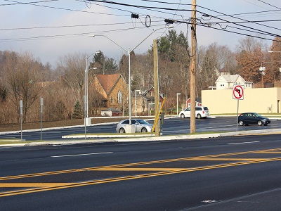
BACKGROUND Trans Associates was initially retained by Hampton Township to complete transportation analysis studies and concept level alignments to address capacity and alignment issues at the intersection of Route 8 and Duncan Avenue. Our firm was then selected by the Township to complete the design plans and documents as part of a PennDOT Partnership project.
SERVICES PERFORMED The project included: • Widening for northbound and southbound left turn lanes on Route 8; • Realigning Duncan Avenue and widening for an eastbound right turn lane; • Installation of a new traffic signal with optimized timings and phasings; • Design of a specialty caisson foundation behind an existing wall for a signal pole; • Providing ADA accessible curb ramps, sidewalks and crosswalks which are physically constrained by an existing retaining wall on the east side of Route 8; • Providing a park-and-ride lot to accommodate Myers Coach Line buses with access drives from Route 8 and Duncan Avenue.
The project area had several physical constraints and challenges such as the bridge carrying Route 8 over Pine Creek south of the intersection, a concrete retaining wall along the eastern side of Route 8, the BP gas station along the western side, and the Duncan Avenue bridge over Gourdhead Run. A regional storm water management project eliminated some physical constraints by replacing the existing Duncan Avenue stone arch bridge with a concrete pre-cast culvert. There were also significant utility coordination issues including avoiding major fiber optic duct banks on both sides of Route 8 and relocating an existing waterline and gas line on the western side of the roadway.
Trans Associates was involved in all aspects of the roadway improvement activities including extensive coordination with PennDOT and Hampton Township, roadway design, drainage design, environmental permitting, right-of-way investigation, coordination and plans preparation, traffic signal design, and construction consultation.
Capital Crossroads SID is is voluntarily funded by more than 500 property owners with the primary purpose of making Downtown Columbus the cleanest, safest, and most attractive commercial area in central Ohio.
Capital Crossroads promotes the downtown with initiatives such as Pearl Market which is set in the middle of the hustle and bustle of Downtown Columbus. The primary objective of Pearl Market is to develop a merchant mix that reflects the rich cultural diversity of central Ohio while encouraging customers to purchase fresh, locally-grown produce and other goods from vendors in the community.
When the market planned an expansion into Lynn Alley, Trans Associates was brought on to undertake the engineering aspects of the alley’s rehabilitation. Services included transportation design, utility coordination, maintenance and protection of traffic and parking design.
Capital Crossroads Special Improvement District (CCSID) was formed in 2001 to help make downtown Columbus “the cleanest, safest and best place to live work and play in central Ohio.”
Capital Crossroads determined that the District would benefit from a Downtown wayfinding program of improved signage in and near the District that directs pedestrian and vehicular traffic to and from dining, recreational, and cultural attractions, special districts, and other sites of interest. The wayfinding program included the design and installation of pedestrian map kiosks, pedestrian-oriented directional signage, parking and parking rate signs, and sidewalk-mounted vehicular directional signs.
Working with CCSID and their sign designers and fabricators, Trans Associates prepared plans for the installation of all signs in the system, working in tandem with the CCSID and their sign designer and fabricator. This included gaining permits from the City of Columbus for the installation of about 55 pedestrian kiosks and 85 vehicular directional signs.